Am Montag, 7.4.2025 wird TUdatalib wegen geplanten Wartungsarbeiten am Speichersystem von 9:00 bis voraussichtlich 9:30 nur eingeschränkt nutzbar sein (kein Datenupload und Download) | Due to scheduled maintenance on the storage system, using TUdatalib will be limited on Monday, April 7 2025 from 9:00 to approx. 9:30 (no data upload or download)
Database of Mineral, Thermal and Deep Groundwaters of Hesse, Germany
Beschreibung
The hydrochemical composition of groundwaters is governing its usability for various purposes (drinking water, thermal water, mineral water, mineral extraction, heat extraction etc.). It also has a huge impact on its technical use since changes of temperature and pressure can result in scaling, corrosion and de-gassing etc. which result in extra costs for remediation measures. Furthermore, the hydrochemistry also controls the fluid properties as for example its viscosity or heat capacity. Knowing the hydrochemical composition is therefore imperative to be able to predict its properties and to foresee technical or economic challenges which might arise during utilization.
For this purpose, we designed and compiled the database of mineral, thermal and deep groundwaters of Hesse, Germany. It includes 1035 published hydrochemical data sets from 560 different measurement points in the entire Hessian territory and some adjacent areas. It has been compiled by the TU Darmstadt in close cooperation with the Hessian Agency for Nature Conservation, Environment and Geology (HLNUG) and the Federal Institute for Geosciences and Natural Resources (BGR) as part of the R&D project Hessen 3D 2.0 (‘3D modelling of the petrothermal and medium deep geothermal resources for power production, direct heat utilization and storage of the federal state of Hesse’) funded by the Federal Ministry for Economic Affairs and Energy (grant number 0325944A).With this publication we provide this database as .xlsx and .csv file. The database includes all available measurements which meet at least one of the following criteria:
- water temperature of at least 20 °C (definition of thermal water)
- solution content of at least 1 g/l (definition of mineral water)
- depth of at least 100 m (definition of the formation water database of the BGR, currently under construction)
- Isotope data without hydrochemical data, mainly Δ13C, 14C and Δ34S
With few exceptions not matching these criteria are nine data sets (#439, 440, 463, 464, 479, 480, 781, 928, 975), located in other states close (≤ 2 km) to the Hessian state border, which are included to improve the spatial coverage. Two data sets (#615, 772) are included to better represent the crystalline Odenwald. In addition, the Sossenheimer Sprudel (#544) is added, although not meeting the criteria, due to its location within Frankfurt and its historical significance. Analyses older than 1910 are integrated to the database, if
a. analyses appear trustworthy due to the experience or reputation of a laboratory or an author,
b. conversions into units valid today can be carried out correctly,
c. the analysis is of interest for longer time series, or if
d. there are no recent analytical data available, but due to the geological-hydrochemical importance of the spring or well, respectively, or due to data distribution, it is of interest to include them.
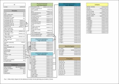
A data set contains up to 122 entries sorted by metadata, references, physico-chemical (sum) parameters, major elements, minor elements, trace elements, dissolved gases, free gases and isotopes (Fig. 1). Further 63 fields – only available in the xlsx-version – serve for semi-automatic data evaluation, control and interpretation, which are complimentary information on the original data set as it was available in the single references. These additions enhance the usability and facilitate the interpretation of the original data sets. Filled fields in light grey in the columns referring to coordinates, altitude, final depth and geological information mark own additions of the data set which were not given in the original reference. Filled fields in light grey in columns concerning the electrical balance and major elements mark own calculations, e.g. bicarbonate from the carbonate hardness or single ions from the electrical balance itself. Filled fields in dark grey indicate comments or explanations available within the observation column, for example additional information, contradicting values in different literature sources or missing data. Electrical balances marked with a red filling indicate deviations larger than ±5%. Cations and anions define the water type (own classification), if they have an equivalent concentration of at least 20%, and are listed with descending ratios.
The data sets mentioned above are further supplemented by 18 data sets with mean values for rock units occurring in Hesse from Ludwig (2013) to allow for a comparison to mean values of the data base for similar rock types or formations. Furthermore, 37 data sets from the Baden-Württemberg, Rhineland-Palatinate or the French part of the Upper Rhine Graben (URG) from Stober & Jodocy (2011), Stober & Bucher (2015) and Sanjuan et al. (2016) were included since only sparse data from literature are available in Hessen for the hydrogeological units of the graben fill of the URG and the Mesozoic to Paleozoic units below.
DFG-Fächer
3.42-01 Geologie3.43-01 Physik des Erdkörpers
3.44-01 Mineralogie, Petrologie und Geochemie
3.46-01 Hydrogeologie, Hydrologie, Limnologie, Siedlungswasserwirtschaft, Wasserchemie, Integrierte Wasserressourcen-Bewirtschaftung
URI
https://doi.org/10.25534/tudatalib-340https://tudatalib.ulb.tu-darmstadt.de/handle/tudatalib/2508.2
Verknüpfte Ressourcen
- Wird zitiert von: DOI:https://doi.org/10.5194/essd-2021-139
Sammlungen
Die folgenden Lizenzbestimmungen sind mit dieser Ressource verbunden:


